The Printup Home - History
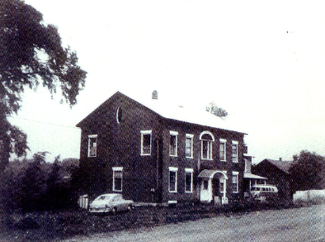
The Printup Home, 50 years or so ago. (given to me by Annie Coddington)
Much of what follows below is taken from County land deeds and from two books: “The Printup Family in America, 1695-1988” by Robert A. Printup, Gateway Press, Baltimore, Md 1989 and "Stephanus Cromwell's Stone Ridge" by Annie Hanchett Coddington (Chickadee Down Press, no date, though after 2007).
The County
In 1772, Tryon County stretched from the St. Lawrence River to Pennsylvania, westward to Lake Ontario (Watertown area) and east to the edge of Warren and Essex Counties. Lands west of it were “Six Nations, Iroquois”. It was later subdivided into “Mohawk” (central Montgomery County east and north to Canada), “Stone Arabia” (western Montgomery County north to Canada), German Flatts (Herkimer County north to Canada and west to Watertown), “Canajoharie” (comparatively small), and “Kingsland” (Oneida Lake east to Herkimer County and considerably south).
Printup (and Local) History Begins
Note: Printup has alternate spellings: "Prentup", "Print", 'Prent", but for the sake of consistency, I will use only the most commonly accepted one - Printup.
A deed dated 10/16/1771 (Cromwell to Cromwell, book 1, page 59) makes mention of the spring: "the spring well below the hill nigh the house where William Printup now possesses that it shall remain in common and free for both parties and heirs...". This places William Printup as living in an upland, south of Dillenbeck Rd. Exactly where Joseph Printup and his family resided prior to 1780 is unknown. But we do know it was on a knoll (therefore - not our place) and had a spring. The area had been plundered, burned, destroyed in 1780 by Sir John Johnson and his Tories, and rudimentary dwellings were re-erected soon afterwards.
10/24/1781
** "William Printup, an Englishman, father of the one named in the context, who was among the early settlers of the Mohawk Valley, was a blacksmith, and resided near the lower Mohawk castle. While there, he was employed by the British government to repair guns, make axes, hatchets, hoes, etc., for the natives. One day when Printup was at work in his shop, an Indian, who had taken umbrage at him from some cause, entered the shop and bade him kneel down and pray. "Pray!" said Printup, "for what ?" "Because I am going to kill you," was the reply. "To kill me? I’ll beat your head in with my hammer," he retorted, raising the instrument he held in his hand, and giving evidence of suiting the action to the word, as he turned upon his red foe. The latter, armed only with a knife, was taken all aback, and seeing the determined look of his antagonist, fled from his shop, hotly pursued by Vulcan in his leather apron, with uplifted hammer. The chase was continued for some distance, in the presence of many Mohawks, who were not a little amused; and who added several loud whoops, crying out, "Killum Print! Cha-etw.go- chetk-e-taw-go !" terrifying the poor fellow so that he buried himself in the recesses of the forest, and never again disturbed the labors of the King's blacksmith. The Indian word Cha-awgo-cheth-etaw-go, signifying Pursue and kill him if you can, was the name by which Printup was ever after called 'by the natives."—/. L. Groat. (From The History of Schoharie County.)
** “This last local foray was commanded by Major Ross and Walter Butler and consisted of 700 Tories and Indians and British regulars. Ross was afterward in command of the British fort at Oswego, when Capt. Thompson came from Fort Plain bearing to the enemy news of an armistice between England and the United States. Of this interesting journey mention is made in a following chapter. October 24, 1781, the enemy broke in upon the Mohawk settlements from the direction of the Susquehanna, at Currytown, where they had so ravaged the country a few months earlier. They burned no buildings as they did not wish their presence yet known to the neighboring militia. That same morning a scouting party went from Fort Plain towards Sharon Springs, there separating, all of them returning to their post except Jacob Tanner and Frederick Ottman, who set out for Currytown, where Tanner wished to visit his family. Near Argusville they came in touch with the enemy, who were approaching the Mohawk by the southwest route. The two American scouts ran down Flat Creek and, throwing away their guns and knapsacks, escaped and spread the alarm. At the Putman place (Willow Basin, in the town of Root below the Nose), they came upon a funeral party attending services over the remains of Frederick Putman, who had been killed by the enemy while hunting martin up Yatesville Creek. Thus warned, the party broke up and its members fled for safety and to warn others.
"The enemy in force, to the number of 700, went from Argusville to Currytown, plundering houses on their way but avoiding the little fort at that place. From Currytown they made for the Mohawk and there came upon and captured the two scouts, Tanner and Ottman, Rudolf Keller and his wife, Michael Stowitts and Jacob Myers, all returning from the Putman funeral, and later took John Lewis near the river. Mrs. Keller was left near Yatesville (now Randall) by the intercession of a Tory nephew. Half a dozen other women just previously taken were also left here, among them Mrs. Adam Fine and a girl named Moyer. The invaders after this did not encumber themselves with any more women prisoners on this raid. Myers was an old man and, on the forced and terrible march which followed the Tory defeat at Johnstown he could not keep up with the party and was killed and scalped.
"Leaving the Yatesville neighborhood, Major Ross led his party on the south side down the Mohawk, taking the new road recently laid over Stone Ridge, into the present town of Glen. On the ridge they came at twilight to the Wood home, and took there John Wood captive. Here Joseph Printup, a lieutenant of militia, was at his son's (William I. Printup) house, as were also Jacob Frank, John Loucks and John Van Alstyne, neighbors. Printup had been cleaning his gun and, as he reloaded it, said: "Now I'm ready for the Indians." Almost at the same instant the advance party was seen approaching the house. Frank and Loucks ran for the woods, Loucks being shot down and scalped and Frank escaping. Printup fired on the advance party. An Indian put his gun to the patriot's breast, but a Tory friend of Printup's, with the Indians, struck the gun down and the Whig lieutenant was hit in the thigh. The Tory interfered and saved Printup's life and then he was made prisoner. Several times during the following march the lieutenant was saved from the Indians' tomahawks by his friend of the enemy. Printup suffered agonies on the way but finally got to Johnstown, where an old Scotch woman, Mrs. Van Sickler (probably the wife of Johnstown's first blacksmith and also Sir William's), interceded for him and he was left at her house. From here he returned to Stone Ridge and was finally cured of his wounds. At the time of his capture Van Alstyne was also made prisoner and he helped Printup along the road. According to the Indian custom, had he not been able to keep up, he would have been at once scalped and killed.” History of the Mohawk Valley: Gateway to the West 1614-1925, Ch. 71, Battles of johnstown and Butler’s Ford
“On the afternoon of October 24th, 1781, a body of the enemy, consisting of nearly seven hundred British and royalist troops and Indians, under Maj. Ross, who was accompanied in the expedition by Maj. Walter Butler, of Cherry Valley memory, entered the Mohawk river settlements, making their first appearance in Curry Town. Passing through that ill-starred place, which had been pretty effectually destroyed the preceding July, they avoided the little fort and did not fire the buildings then standing, from fear of frustrating part of their enterprise. Proceeding from thence to the Mohawk valley, they met and captured Jacob Tanner, Rudolf Keller, and his wife, Federick Utman, Michael Stowits, and Jacob Myers, citizens of Curry Town, as they were returning from the funeral of a Mrs Putman, who had been buried that afternoon near Lasher's canal tavern. Mrs Keller was left near Yates's, by the interposition of a nephew who was among the tories, and the party afterwards avoided capturing females. Mr Myers, who was far advanced in years, being unable to endure the fatigues of so long and rapid a march, was killed and scalped on the way to Canada, and his body there left a prey for wild beasts. - John Keller.
"Maj. Ross proceeded down the Mohawk, taking the new road but recently laid over Stone Ridge, in Root. On the Ridge they captured John Wood, the son of a widow, at whose house they arrived near twilight. Joseph Printup, a lieutenant of militia, was living at that time near the residence of his son, the late William I. Printup. He was at home as Ross approached, and Jacob Frank, a brother-in-law, John Loucks and John Van Alstyne, neighbors, were also at his house. Printup had just been cleaning his gun, and as he loaded it and returned the ram-rod, he remarked, " Now I am ready for the Indians! " He had scarcely uttered the words, when an advance party of them, just at dusk, was seen approaching the door. Frank and Loucks sprang out of the house and fled up the hill south; the former was shot down, however, and scalped, but the latter unscathed, effected his escape. As the Indians approached his door, Printup fired at them, when they rushed into the house, and one of them, placing the muzzle of his gun near Printup's breast, drew the trigger, - at which instant the latter struck the weapon down, and its bullet passed through the fleshy part of the thigh. A tory acquaintance, who was with the enemy, then interfered to save Printup's life, and he was taken prisoner, soon after which the enemy resumed their march down the river. A little distance east of Printup's, a halt was made at a large rock beside the road to kill him; but the tory again interposed, and declared he should not be killed while he could keep up with his captors. Van Alstyne lent his services to aid his wounded companion, who leaned upon his shoulder, and was thus enabled to continue the journey. - John, a son of Joseph Printup.
"Jacob, a brother of John Van Alstyne named above, resided on the Stone Ridge at this time. He had been to attend a religious meeting near the present village of Fultonville, and was returning home on horseback, when he unexpectedly fell in with the enemy. A large Indian seized the bridle, and several of his fellows drew Van Alstyne from the horse a prisoner, and the former mounted. The Indian was hardly upon his back, when the horse, not fancying his new rider, reared, floundered and soon left him upon the ground with a broken shoulder. The sagacious animal then set off at full speed, and the enemy opening to the right and left, gave him a free passage; and not caring to fire on him, he escaped from then and returned home, greatly alarming Van Alstyne's family as may be supposed. The prisoner was divested of part of his clothing and the march resumed. - Cornelius G. Van Alstyne.
"Charles Van Epps, who resided where the dwelling of Evert Yates now stands in Fultonville, escaped with his family as the enemy approached. Evert Van Epps, a nephew of the former, started in the evening, which was very dark, to go to his uncle's, (distant from his own dwelling scarcely one quarter of a mile,) to enquire after the news. Possibly he had heard the firing at Printup's two miles above, and suspected all was not right. He had not proceeded half way to his uncle's residence, when, as he had crossed a small bridge and was opening a swing gate near the end of it into the road, in the present garden of John Mead, he heard the click made by cocking several guns, and a voice sternly demand "Who's there?" The first thought of Van Epps, who could distinguish no visible object, was, to turn and flee; but supposing some of the enemy might be in his rear, or that he would instantly be fired at if he attempted to run, he remained at the gate and was soon surrounded by a hostile party, who were on their way to his house. On securing this prisoner, the enemy again moved forward. - John E., son of Evert Van Epps.
"Fultonville... has but few historic associations, and is but the fourth of importance in Montgomery county; Amsterdam, Fort Plain and Canajoharie each having a population more than twice as large.... Fultonville was named at a meeting of the citizens soon after it began its existence, in honor of Robert Fulton, and has sprung up on the Erie canal since its completion, and contains an hundred dwellings, with a population of six hundred inhabitants. A good part of the village is now built on ground called in the Revolution, "Van Epps Swamp." The small dwelling seen in the extreme left of the picture, was erected just after the war of the Revolution closed, by John Starin. This house stands near the bank of the river, and was for a long time known as a public house. Indeed, before the Mohawk turnpike was constructed, a line of stages was established on the north side of the river, and at this inn the passengers from Albany usually dined. About the year 1795, this house was the western termination of the mail-route in the Mohawk valley, which route was afterwards extended to Herkimer, and still later to Utica. When the mail-route ended at the house in question, to which it was borne once a week, Myndert Starin, a son of the inn keeper, as often carried it to Johnstown, four miles north, then its place of destination, either on foot or on horseback. In the river, nearly opposite this dwelling, may be seen the rock which originated a name for the ancient village of "Caughnawaga," on the north side, which, as already stated, literally signifies, "Stone in the water." A few rods from the site of the dwelling near the bank of the river, seen in the right hand of the picture, (more ancient site of the Charles Van Epps dwelling,) stood a small block- house, erected near the close of the Revolution.
"But to return to the war path. Seasonable alarm was communicated by John C., a son of Charles Van Epps, who chanced fortunately to be on horseback, to the river settlers below, who made their escape. On arriving at a brook in a small ravine, near the present site of John Van C. Alstyne's store, at Auriesville, John Van Alstyne said to his fellow prisoner, Printup, " Were it not for you, I would now make my escape." His wounded friend replied - "Never mind me: if you can escape, do so, and leave me to my fate." They were walking between two Indians, when Van Alstyne sprang out, dashed up the ravine with the fleetness of an Indian, and escaped: the enemy did not care about firing on him from motives of policy. Again the Indian who had captured Printup was about to sink a tomahawk into his head, but was prevented by the Tory who had before interdicted such an occurrence. From Auriesville, the enemy proceeded to Fort Hunter, forded the Schoharie near its mouth and prosecuted their enterprise as far as Yankee Hill, in the present town of Florida. From thence, becoming fearful of pursuit, the main body forded the Mohawk and directed their course to Johnstown. Small parties of the Indians, however, carried their designs still further; but Capt Wm. Snook, who had been notified of their approach, sent Conrad Stein, an officer under him, to warn the settlers of danger, and they generally effected their escape, with a portion of their property. A short time before the Revolution, Matthias Wart and Marcus Hand, Germans, settled in the interior of this town. The invaders burnt the dwellings of Wart, Henry Rury, Captain Snook, John Stein, Samuel Pettingell, Wm. DeLine, Patrick Connelly, George Young, and several others in the neighborhood. Near the house of Rury, a man named Bowman was captured, and in attempting his escape, soon after, was killed. The female part of Rury's family, consisting of his wife, her sister Harriet Notman, and a little girl named Jane Shelp, were made prisoners by One Armed Peter; who conducted them some distance from the house. Harriet had a child in her arms, and falling down with it, Peter insisted on carrying it, as supposed, to prevent his being shot, should he meet an American marksman. Arriving at a by-place, the party halted, and the Indian asked the young women if they had any money. An outside pocket was then worn over the dress, and Harriet, loosening hers, handed it to him. From it he transferred two dubloons to his own person, and then returned it. Giving a loud yell, it was responded to by some half a dozen so terrific, as to cause Miss Jane to faint away beside a log. Being joined by several of his comrades, Peter gave the prisoners their liberty, and no further injury or violence was offered them.
"The suffering of Printup must have been acute while crossing the Schoharie and Mohawk rivers, the waters of which were then cold. On arriving at Johnstown, Mrs Van Sickler, a Scotch woman, and resident of the place, interceded in his behalf, and he was left at her house: from whence he returned home and was cured of his wounds. - Van Epps, Printup and John Hand. At Johnstown, Hugh McMonts, a constable, and William Crowley were surprised and killed. - Mrs. Penelope Forbes.” History of Schoharie County, Jeptha R. Simms, 1845, Chapter XVI
6/2/1788 - Joseph Printup (b. 1746) bought 257.25 acres of land for 400 pounds, Lot 3 of the Ten Eyck Patent. But no deed has been found. This was the Moore farm. It is known that the Mohawk River was the north boundary. Note that they were still using the British pound instead of Confederacy money, which was little trusted. It was not until the Consitution was written that US currency began to be well accepted. Joseph was the son of William and also had a brother of the same name. He had started as a tenant, took part in the Battle of Oriskanky in 1777 as a Lieutenant. Four years later, the event chronicled above took place as he was living in what was called the Joseph Moore farm (Printup Home area); his brother William lived nearby. Joseph married Annetje/Hannah Frank and had 5 children: William J (b. 1766), Andrew (b. 1769), Sarah (b. 1773), John (b. 1779) and Jane (b. 1783). In 1794, Joseph was the Commissioner of Highways and was laying out roads and making assessments for the Town of Charleston.
Land Wheeling and Dealing, Chain of Title:
A perusal of oldest records makes it clear that those old dudes were buying and selling land at a rate perhaps even faster than we see today. People often owed money on their land and many times were foreclosed upon or forced to sell. There were many sheriff's sales back then and I did not find many examples of mercy. They often installed tenants on their property or had laborers live there. It feels as if it was something of a cut-throat time and I suspect many of the more well-to-do folks back then fully intended to supplement their income by real estate speculation. The Printup and Starin families were in the thick of this. By the Civil War, things had smoothed out some and folks seemed to hold on the land longer as new families became land-owners.
I have included information below on additional parcels other than just The Printup Home. There are multiple reasons for this, primary of which was that it adds interest, background, and side lights the story of our home. Also, early Printups seemed to have some aversion to filing deeds and they happened to do a lot of land dealing, which only exacerbates the problem. Old records are hard enough to peruse without having that happen! And then there was the problem of names having multiple spellings, which was rampant at the time, perhaps related to illiteracy. There are few old maps available on which to definitively locate people's homes. Some records have been lost. Compounding the difficulties, Town and Patent lines, even County lines did change once in a while, back in the early days. The result can be expected - confusion. Someone with some skill and more time than I have may be able to make more sense of things. I'd rather give you extra information than not enough.
It is of special interest to mention that at the time The Printup Home was built, the family was considered the County's wealthiest. I would not have otherwise guessed this: yes, the home was obviously built by someone of great means, but the very wealthiest? Wow.
1796 - 200 acres (Lot #30) was sold to Adam Frank by one of the Printups for 50 pounds. Isn’t that interesting? No US dollars.
1797 - 292 acres (Lot #23) was sold to Phillip Starring (Starin) for 2000 pounds. Still no dollars.The Starins were local land barons, wealthy, and it showed.
Prior to 1800, the South Shore Rd (now Route 5S) was more important than the Mohawk Turnpike (now Rte 5). On the latter, there was an inn about every mile, as it was a lucrative business, especially for those that could provide stabling. For those that didn’t, the horses were covered with an oil cloth.
4/17/1801 - Henry Ten Eyck sold 286.5 (also mentioned as 288) acres to Dr. Joseph Printup (d. 1837). 5 lots of land were involved at a price of $8500 (US money now). It included the TenEyck Dutch barn which, while high and dry, was much more accessible than his former barn, with no steep slope for his horses to drag crops up. He immediately began building homes, barns, mill ponds and mills, dams and bridges. Lots 31 began at the west bank of the Wasontha (Printup) Creek and was about 235 acres. Another 16.5 and a second parcel of 15.5 acres was in the Kennedy Patent, still bounded on the north by the Mohawk. Lots #2 had 19.5 acres, with the Mohawk as the north boundary. Lastly, there was a small 1 acre lot on the Kennedy patent at the edge of a small stream coming from the swamp, but on the north side of the river, a landing place for a ferry, which Printup operated. William J Printup lived in his father's former homestead on the Ten Eyck Patent while his father (Joseph) built a new home on Wasontha Creek, north of the River Rd. William J's brother John lived west of Wasontha Creek on the Kennedy Patent and farmed the river flats. Joseph built a new home, an orchard, and barns there on a knoll overlooking the river flats. It would later front the Printup Dry Dock and the Canal. Wasontha Creek was on the land. His son0in-law Ephraim Ownen (married Sarah) probably built the gristmill, maybe around 1806. At this time, this was considered the Town of Charleston.
5/31/1806 - Joseph (d. 1831) & Annetje/Hannah Printup sold part of Great Lots 2 & 3 of the Ten Eyck Patent to William Smith. The home here was located a couple of miles south, on the upland area.
8/16/1806 - Joseph & Hannah Printup, for $1500 (or $1005 - someone probably transposed figures when reporting), sold 26 acre, home, and a grist mill to Ralph Simpson. (What happened to Annetje? Or was this another Joseph Printup?) With the sale came the right to build two new mill dams across the creek.
11/29/1817 - a mortgage that was recorded refers to a deed that wasn't ion which Joseph Printup sold his son-in-law William Smith 50 acres of Lot 3 on the Ten Eyck Patent. A second deed, also unrecorded, was mentioned in the mortgage. This was to Nicholas VanPatten for 100 acres. Both were outside of the area of our immediate interest.
1820 - Joseph Printup sold a lot "by paper title" to his son John (16.5 and 15.5 acre lots in the Kennedy Patent). Deed not recorded. John was married to Cornelia, who committed suicide a few years later. They had lived here prior to the sale.
1823 - Town of Glen formed from the Town of Charleston. Original name of the hamlet was Voorheesville.
1/16/1824 - Joseph Printup (b.1799, d. 1831, no will) sold 15 acres south of his homestead to his son John, who apparently did not value recording deeds. This included the gristmill and sawmill that were on the Wasontha (Printup) Creek. This deed was not found either, just a reference to it. But on the same date, John also bought 132 acres from his father Joseph and that deed was recorded. John's wife Cornelia committed .suicide on 4/5/1826. Accounts vary on how she did this. John later remarried, Mrs.Lenderson, a widow with 2 sons. Later (1827-29, 1836-38), John sued one step-son for room and board. After building a new home, Joseph and his wife Hannah vacated their home in the Ten Eyck Patent to their son William J and his family.
1825 - Erie Canal was finished in this area.
7/3/1827, 7/21/27, & 12/2/28 - Sheriff's sale of the goods and cattle of Wm Leonard to Wm Printup and John P. Yates. They also took land because the chattels were insufficient to pay the debt. Town of Root.
5/29/28 - Jacob J & Caroline Fraleigh sold to Andrew Printup (b. 1802, d. 1870), for $240, land in the Town of Root. This may or may not be important to the history of the home, depending upon where the Town lines were back then. Anyway, Andrew Printup bought what is known as the Lewis Putnam blacksmith shop in Stone Ridge. He sold it for $225 two years later and moved in with his aging grandfather, Joseph. The home there burned in 1905. Andrew (b. 10/21/1802) was the son of John & Cornelia Printup and married Angeline Emmons on 5/7/1825. The man who bought it from him, James Wagner, had rented it before the purchase. Known as the "Wagner Estate:", it eventually fell into disrepair, abandoned, and was sold for taxes.
1829-30 - THE PRINTUP HOME was built. It is the only surviving brick colonial home for several miles in any direction. Town records use the date 1830, but Annie Coddington insists it was 1829. I'd trust her figure before the Town's.
**Joseph Printup (b 1746, d. 1831, the son of Wm & Sarah Printup), gave a deed to Wm Henry Printup who married in 1830. I also read that Joseph died without a will and the property was divided by his sons John and William J. The survey was made by C.H. Putman in March 1833. Stone Ridge was settled as early as 1780, the home here built in 1830 or as Annie Coddington asserts, 1829. The canal was 10-15’ from the house and was a stopping place for barges. Once part of an “enormous” estate. The Printup name was of Hugenot origin. Wm Printup Jr, the scion, fathered some Indian children. Wm. III was baptized at Queen Ann’s Chapel, an Indian Church, which may indicate he had Indian blood. Many of the early family members were illiterate.
*12/29/1830 John Van Epps Yates sold to Wm J Printup (b. 1766 at the tenant homestead of his father Joseph in what was recently the Joseph & Marie Moore home - it is unclear to me, for several reasons, if this was The Printup Home or not, d. 1842) part of the Yates farm for $200, land along the Mohawk opposite Caughnauwaga Bridge, one acre, recorded 1/1/30. Apparently it was surveyed land. William J was quite the land speculator at this time and was reputed to be the richest man in the County. But he, like his father, recorded few of the deeds. He also was a man who readily lent money and, at his death in 1842 was owed considerable sums. He and his immediate family are buried in the William J Printup Family Cemetery, located on a knoll south of the Printup Home. I have looked for this unsuccessfully, not a surprise since it is reputedly very difficult to find. He deeded his widowed daughter, Jane Smith, the Tavern Stands and 5 acres which Elias Johnson operated. Two grandaughters each got a 100 acre farm and $2000 cash. She also got another tavern and 15 acres, which was located across the Mohawk River. Her new husband I(#2 - James Gardner) mortgaged both of them for $1200. At that time Nicholas Sager (who married John Printup's daughter Nancy, but otherwise seems to be historically invisible) operated the one at Stone Ridge. But by 1844, they were both foreclosed upon and sold at public auction. Mary A. Davis ended up with the one at Stone Ridge, for $575 ($625, in another section of the same source), and she continued to rent it out. All was not lost as Jane also inherited the VanAntwerp farm in Glen and she lived until 1876, when she died at th4 age of 81. The Tavern Stand was razed when the Thruway went through.
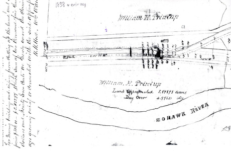
**1830-32 Stone Ridge Dry Dock 1830-1832 (canal realigned from this course 1857)
(J. Printup 1830, ND; Peter W. & William Printup 1851, 1857) Hamlet of Stone Ridge, Town of Glen, Montgomery County South side of canal 9.0 km (5.6 mi) west to Sprakers; 5.5 km (3.4 mi) east to Fultonville (this would be about a mile further west than the Printup House)
1831 - Joseph Printup dies, intestate. His sons William J and John, along with son-in-laws Ephraim Owen and William A. Smith divided his holdings. The land had been surveyed but the map has since been lost.
8/3/1831 - Joshua & MaryAnn Young et al sold to Wm J Printup, Town of Johnstown. William J (d. 1842) was known as both a land speculator and a landlord. He and his heirs owned several of the lots in Stone Ridge.
5/16/1832 - Abraham & Cathy Van Alstyne sold to Andrew Printup Lot #3, a ~5 acre woodlot in the Town of Glen.
3/12/1833 - John and his second wife, Winnity(nee Lederson), sold Andrew (d.1870) a 30 acre lot along the TenEyck/Kennedy Patent line, the lot where the grist mill and sawmill and other buildings were located. The price was $2000. The mills had been operated by Joseph Miller and William Pulver. Andrew had been living at this time in his grandfather's home (Joseph). They moved to Toledo in 1835, lured by the promise of virgin farmland the the Federal Government had basically stolen from the Indians. The same year, John's other sons -Jacob, Joseph, Peter (b. 1815) - left home to work on the railroad. Four years later, Daniel left for Georgia, to be followed there by William (b. 1821), Henry and Evert some years later.
3/13/1833 - Joseph's land was surveyed into 4 parcels, one for each son (John, William J) and daughter (Jane Printup Smith, Sara Printup Owen). The original map has not been found, but the deeds are carefully worded. Each one got 44 acres of upland and 8 of river flats.
4/20/1833 - John Printup sold to William Smith a 3 acre lot for $150, the home of Andrew Printup and also the home where Joseph had lived until his death.
1/22/1834 - James McKerman & Wm I Printup in the Town of Johnstown (Montgomery County - which originally included Fulton County as part of it)
c.1834 - Dr. Joseph Printup (b. 1797, d. 1837) erected an elegant 2 story home in Stone Ridge on 5 acres of land on what had once been John Printup's land. He and his family may not have lived in it immediately but were definitely there in 1837 when there is a Judgment on file regarding the theft of his horse. The home and lot came into possession of his father, William J. Printup who leased it out as a Tavern Stand/Inn. No one knows how he came to get it, but it is likely that he got it after Dr. Joseph's wife remarried in 1838. It was not uncommon in those days for Wills to have a clause disinheriting the wife if she remarried. Anyhow, William J. rented it out to Elias Johnson, an innkeeper. After William J died, it went to his widowed daughter Jane Printup Smith (2/20/1840). Later she married James J. Gardner (1841). Together, they mortgaged the property for $1200. The mortgage was reassigned to Garret V. Davis, whose widow Mary A. eventually foreclosed on it via public auction for $575 (2/17/1844). She continued to rent it out. By 5/30/1868, she had remarried and was now Mrs. William Hall. She sold the Tavern Stand to Henry Chapman for $900. He used it as his home. By 1942-44, it went to the County for delinquent taxes and Chapman's daughter Mary Johnson bought it for $285.75. So much for appreciation.
5/22/1834 - William J Printup sold a lot to John Printup.
3/16/1836 - William J Printup sold to William A and Jannetje/Jane Smith his 1/4 interest in the 3 acre lot and home. This is the 1822 Erie Canal Dry Dock. No deeds from his siblings have been found.
5/2/1836 - Barney McKernan sold to Wm J Printup land in the Town of Johnstown
5/12/1837 - Judy Garrison sold to Wm J Printup, Town of Johnstown.
9/14/1837 - David & Catherine Eacker (?) sold to Wm Printup land in the Town of Root, 1.5 acres, formerly owned by John Bebins, later by Nicholas Starin.
11/14/1837 - Frederick & Catherine Dockstader sold to Wm J Printup in the town of Mohawk (probably somewhere else)
3/29/1838 - Henry J & Wm B Devendorf - -reference to land formerly in Charleston but now in Root. What does this mean? Town lines changed.
5/10/1838 - Hugh McKernan sold to Wm J Printup more land in Town of Johnstown.
7/1/1839 - Mark & Magdalene Dockstader sold to Wm I Printup in the Town of Mohawk. Probably nothing concerning the history of the home.
7/1/1844 - John Printup sold to Peter W & Wm Printup in the Town of Mohawk. Ditto.
7/22/1844 - John Printup sold to Peter & Wm Printup (who were from Augusta, Georgia and Richmond, Va.) land in the Ten Eyck Patent in the Town of Glen. Personal property of stock and machinery plus furnishings was included, along with 132 acres in the Ten Eyck Patent. Held back from the sale were 15 acres, a house, grist mill, saw mill, another 44 acres of upland and 7 acres of river flats. By adding this up, the original property would have been nearly 200 acres. On the same date, he also sold to them 50 acres of uplands and a "house lot" of 15 acres. My presumption is that they got it all, but in two deeds.
12/6/1844 - Cornelius & Catherine Hanson sold to Peter & Wm Printup in the Town of Glen
5/15/1845 or 1844 - John Printup, son of Joseph and Hannah Frank Printup, William I's brother sold his farmstead in Stone Ridge to his sons Peter W and William (of Augusta, Georgia). Note: I found two dates for this transaction, the other being1844. His sons (labor force?) gone from home, he had been in debt and was forced to sell the farm. They got 208 acres for $5000 and John was spared the shame of a sheriff's sale. Included in the sale were 132 and 31 acre lots in Glen, also the 51 acres (44 upland, 7 river flats) and the one acre lot across the river, but not the 15 acre lot with the grist and sawmills. Shortly afterwards, John burned to death in a house fire while trying to save an 8 year old grandchild, who also died there. The stepson Cornelius that he had sued died suspiciously, or auspiciously, on June 5th.The home was rebuilt by his sons onto the original foundation and a cheese house added for their sister Nancy. His lots had been occupied by Nicholas Starin as Printup had been the landlord.
7/22/1844 - Peter W and William of Atlanta got from, John 2 more lots: 50 acres in Glen (Ten Eyck Patent) and the 15 acres with the mills. $1000. The 15 acres was known as the "house lot", where he lived, and was sandwiched between the river and the road.
11/28/1845 - William J. Printup's heirs owned a lot in Stone Ridge. William was buried in the family cemetery before that date, having died in 1842. Jane Printup Smith Gardner, his daughter was the eventual heir and sold three lots there to her daughter Harriett Smith Quackenbush for $500.
7/11/1848 - Peter W & William Printup of Georgia gave a 100 year lease on land for a school
**Wm Printup I, father to Wm. H, buried 1849, may have died 1845 though. There were barns across the road from the home and a cemetery behind them. The barns are now long gone and the cemetery all but impossible to find. It is on another's land now. Wm. H was born 1835, died 1873, and was a Lt. Cl. in the Civil War. Mustered out for ill health. In 1842, at age 6, he inherited the home from his grandfather, Wm I. He later bought a home in Fultonville, selling the home in 1867 to Peter Nellis, along with 162 acres.
9/22/1846 - There was an "article of Agreement" signed for the 5 year lease at $222/year for a 300 acre farm owned by Peter W and William Printup to Frederick J. Starin and Erastus Tiffany. They had erected a new home to replace that lost to the fire and wanted to rent it to get a return on their investment. Their sister Nancy and a Harriet Gardinier had a tenancy and were to receive another $30/year.
7/11/1848 - The same Peter W and William Printup leased a 1/10 acre lot to be used for a school. The school at Stone Ridge operated until 1953 when the Fonda-Fultonville Central School was formed.
7/26/1850 Mark & Elizabeth Loucks sold to Daniel S. Printup of Rome, Georgia land in the Town of Glen which bordered the Printup cemetery. Or perhaps it was a cemetery lot, 1100ft2 for $12 (that’s $475/acre!).
4/10/1851 - Peter W and William Printup sold land to Arie Van Wie (with Frederick Starin as tenant). They reserved the home used by Jacob Quackenbush. On or about this time Marks Loucks sold the family cemetery on Mill Rd (Dillenbeck Rd today) back to the Printup family - for $12.
1/14/1852 - Peter W and his wife Jane and William Printup sold the farm to the same VanWie, a total of 270 acres, which was in three sections, all for $8400. The school house lot was reserved. The property consisted of 199 acres of uplands and 8 of flats, with an additional 65 acres in the homestead lot. Van Wie died in 1877 and his land (he'd added to it) went to his son Fletcher.
3/4/1853 - Wm A & Jane M Mears sold to David H. Printup of Rome, Ga, a home and lot in Fultonville.
6/13/1853 - Ahijan & Deborah Jones sold to David H. Printup (of Fultonville, now) something in the Village of Fultonville.
9/12/1853 - Cornelius Gardinier & Walter L. VanDenBurgh sold to David H Printup Mertens Vorhees’ home in Fultonville, which bordered the Erie Canal.
The County
In 1772, Tryon County stretched from the St. Lawrence River to Pennsylvania, westward to Lake Ontario (Watertown area) and east to the edge of Warren and Essex Counties. Lands west of it were “Six Nations, Iroquois”. It was later subdivided into “Mohawk” (central Montgomery County east and north to Canada), “Stone Arabia” (western Montgomery County north to Canada), German Flatts (Herkimer County north to Canada and west to Watertown), “Canajoharie” (comparatively small), and “Kingsland” (Oneida Lake east to Herkimer County and considerably south).
Printup (and Local) History Begins
Note: Printup has alternate spellings: "Prentup", "Print", 'Prent", but for the sake of consistency, I will use only the most commonly accepted one - Printup.
A deed dated 10/16/1771 (Cromwell to Cromwell, book 1, page 59) makes mention of the spring: "the spring well below the hill nigh the house where William Printup now possesses that it shall remain in common and free for both parties and heirs...". This places William Printup as living in an upland, south of Dillenbeck Rd. Exactly where Joseph Printup and his family resided prior to 1780 is unknown. But we do know it was on a knoll (therefore - not our place) and had a spring. The area had been plundered, burned, destroyed in 1780 by Sir John Johnson and his Tories, and rudimentary dwellings were re-erected soon afterwards.
10/24/1781
** "William Printup, an Englishman, father of the one named in the context, who was among the early settlers of the Mohawk Valley, was a blacksmith, and resided near the lower Mohawk castle. While there, he was employed by the British government to repair guns, make axes, hatchets, hoes, etc., for the natives. One day when Printup was at work in his shop, an Indian, who had taken umbrage at him from some cause, entered the shop and bade him kneel down and pray. "Pray!" said Printup, "for what ?" "Because I am going to kill you," was the reply. "To kill me? I’ll beat your head in with my hammer," he retorted, raising the instrument he held in his hand, and giving evidence of suiting the action to the word, as he turned upon his red foe. The latter, armed only with a knife, was taken all aback, and seeing the determined look of his antagonist, fled from his shop, hotly pursued by Vulcan in his leather apron, with uplifted hammer. The chase was continued for some distance, in the presence of many Mohawks, who were not a little amused; and who added several loud whoops, crying out, "Killum Print! Cha-etw.go- chetk-e-taw-go !" terrifying the poor fellow so that he buried himself in the recesses of the forest, and never again disturbed the labors of the King's blacksmith. The Indian word Cha-awgo-cheth-etaw-go, signifying Pursue and kill him if you can, was the name by which Printup was ever after called 'by the natives."—/. L. Groat. (From The History of Schoharie County.)
** “This last local foray was commanded by Major Ross and Walter Butler and consisted of 700 Tories and Indians and British regulars. Ross was afterward in command of the British fort at Oswego, when Capt. Thompson came from Fort Plain bearing to the enemy news of an armistice between England and the United States. Of this interesting journey mention is made in a following chapter. October 24, 1781, the enemy broke in upon the Mohawk settlements from the direction of the Susquehanna, at Currytown, where they had so ravaged the country a few months earlier. They burned no buildings as they did not wish their presence yet known to the neighboring militia. That same morning a scouting party went from Fort Plain towards Sharon Springs, there separating, all of them returning to their post except Jacob Tanner and Frederick Ottman, who set out for Currytown, where Tanner wished to visit his family. Near Argusville they came in touch with the enemy, who were approaching the Mohawk by the southwest route. The two American scouts ran down Flat Creek and, throwing away their guns and knapsacks, escaped and spread the alarm. At the Putman place (Willow Basin, in the town of Root below the Nose), they came upon a funeral party attending services over the remains of Frederick Putman, who had been killed by the enemy while hunting martin up Yatesville Creek. Thus warned, the party broke up and its members fled for safety and to warn others.
"The enemy in force, to the number of 700, went from Argusville to Currytown, plundering houses on their way but avoiding the little fort at that place. From Currytown they made for the Mohawk and there came upon and captured the two scouts, Tanner and Ottman, Rudolf Keller and his wife, Michael Stowitts and Jacob Myers, all returning from the Putman funeral, and later took John Lewis near the river. Mrs. Keller was left near Yatesville (now Randall) by the intercession of a Tory nephew. Half a dozen other women just previously taken were also left here, among them Mrs. Adam Fine and a girl named Moyer. The invaders after this did not encumber themselves with any more women prisoners on this raid. Myers was an old man and, on the forced and terrible march which followed the Tory defeat at Johnstown he could not keep up with the party and was killed and scalped.
"Leaving the Yatesville neighborhood, Major Ross led his party on the south side down the Mohawk, taking the new road recently laid over Stone Ridge, into the present town of Glen. On the ridge they came at twilight to the Wood home, and took there John Wood captive. Here Joseph Printup, a lieutenant of militia, was at his son's (William I. Printup) house, as were also Jacob Frank, John Loucks and John Van Alstyne, neighbors. Printup had been cleaning his gun and, as he reloaded it, said: "Now I'm ready for the Indians." Almost at the same instant the advance party was seen approaching the house. Frank and Loucks ran for the woods, Loucks being shot down and scalped and Frank escaping. Printup fired on the advance party. An Indian put his gun to the patriot's breast, but a Tory friend of Printup's, with the Indians, struck the gun down and the Whig lieutenant was hit in the thigh. The Tory interfered and saved Printup's life and then he was made prisoner. Several times during the following march the lieutenant was saved from the Indians' tomahawks by his friend of the enemy. Printup suffered agonies on the way but finally got to Johnstown, where an old Scotch woman, Mrs. Van Sickler (probably the wife of Johnstown's first blacksmith and also Sir William's), interceded for him and he was left at her house. From here he returned to Stone Ridge and was finally cured of his wounds. At the time of his capture Van Alstyne was also made prisoner and he helped Printup along the road. According to the Indian custom, had he not been able to keep up, he would have been at once scalped and killed.” History of the Mohawk Valley: Gateway to the West 1614-1925, Ch. 71, Battles of johnstown and Butler’s Ford
“On the afternoon of October 24th, 1781, a body of the enemy, consisting of nearly seven hundred British and royalist troops and Indians, under Maj. Ross, who was accompanied in the expedition by Maj. Walter Butler, of Cherry Valley memory, entered the Mohawk river settlements, making their first appearance in Curry Town. Passing through that ill-starred place, which had been pretty effectually destroyed the preceding July, they avoided the little fort and did not fire the buildings then standing, from fear of frustrating part of their enterprise. Proceeding from thence to the Mohawk valley, they met and captured Jacob Tanner, Rudolf Keller, and his wife, Federick Utman, Michael Stowits, and Jacob Myers, citizens of Curry Town, as they were returning from the funeral of a Mrs Putman, who had been buried that afternoon near Lasher's canal tavern. Mrs Keller was left near Yates's, by the interposition of a nephew who was among the tories, and the party afterwards avoided capturing females. Mr Myers, who was far advanced in years, being unable to endure the fatigues of so long and rapid a march, was killed and scalped on the way to Canada, and his body there left a prey for wild beasts. - John Keller.
"Maj. Ross proceeded down the Mohawk, taking the new road but recently laid over Stone Ridge, in Root. On the Ridge they captured John Wood, the son of a widow, at whose house they arrived near twilight. Joseph Printup, a lieutenant of militia, was living at that time near the residence of his son, the late William I. Printup. He was at home as Ross approached, and Jacob Frank, a brother-in-law, John Loucks and John Van Alstyne, neighbors, were also at his house. Printup had just been cleaning his gun, and as he loaded it and returned the ram-rod, he remarked, " Now I am ready for the Indians! " He had scarcely uttered the words, when an advance party of them, just at dusk, was seen approaching the door. Frank and Loucks sprang out of the house and fled up the hill south; the former was shot down, however, and scalped, but the latter unscathed, effected his escape. As the Indians approached his door, Printup fired at them, when they rushed into the house, and one of them, placing the muzzle of his gun near Printup's breast, drew the trigger, - at which instant the latter struck the weapon down, and its bullet passed through the fleshy part of the thigh. A tory acquaintance, who was with the enemy, then interfered to save Printup's life, and he was taken prisoner, soon after which the enemy resumed their march down the river. A little distance east of Printup's, a halt was made at a large rock beside the road to kill him; but the tory again interposed, and declared he should not be killed while he could keep up with his captors. Van Alstyne lent his services to aid his wounded companion, who leaned upon his shoulder, and was thus enabled to continue the journey. - John, a son of Joseph Printup.
"Jacob, a brother of John Van Alstyne named above, resided on the Stone Ridge at this time. He had been to attend a religious meeting near the present village of Fultonville, and was returning home on horseback, when he unexpectedly fell in with the enemy. A large Indian seized the bridle, and several of his fellows drew Van Alstyne from the horse a prisoner, and the former mounted. The Indian was hardly upon his back, when the horse, not fancying his new rider, reared, floundered and soon left him upon the ground with a broken shoulder. The sagacious animal then set off at full speed, and the enemy opening to the right and left, gave him a free passage; and not caring to fire on him, he escaped from then and returned home, greatly alarming Van Alstyne's family as may be supposed. The prisoner was divested of part of his clothing and the march resumed. - Cornelius G. Van Alstyne.
"Charles Van Epps, who resided where the dwelling of Evert Yates now stands in Fultonville, escaped with his family as the enemy approached. Evert Van Epps, a nephew of the former, started in the evening, which was very dark, to go to his uncle's, (distant from his own dwelling scarcely one quarter of a mile,) to enquire after the news. Possibly he had heard the firing at Printup's two miles above, and suspected all was not right. He had not proceeded half way to his uncle's residence, when, as he had crossed a small bridge and was opening a swing gate near the end of it into the road, in the present garden of John Mead, he heard the click made by cocking several guns, and a voice sternly demand "Who's there?" The first thought of Van Epps, who could distinguish no visible object, was, to turn and flee; but supposing some of the enemy might be in his rear, or that he would instantly be fired at if he attempted to run, he remained at the gate and was soon surrounded by a hostile party, who were on their way to his house. On securing this prisoner, the enemy again moved forward. - John E., son of Evert Van Epps.
"Fultonville... has but few historic associations, and is but the fourth of importance in Montgomery county; Amsterdam, Fort Plain and Canajoharie each having a population more than twice as large.... Fultonville was named at a meeting of the citizens soon after it began its existence, in honor of Robert Fulton, and has sprung up on the Erie canal since its completion, and contains an hundred dwellings, with a population of six hundred inhabitants. A good part of the village is now built on ground called in the Revolution, "Van Epps Swamp." The small dwelling seen in the extreme left of the picture, was erected just after the war of the Revolution closed, by John Starin. This house stands near the bank of the river, and was for a long time known as a public house. Indeed, before the Mohawk turnpike was constructed, a line of stages was established on the north side of the river, and at this inn the passengers from Albany usually dined. About the year 1795, this house was the western termination of the mail-route in the Mohawk valley, which route was afterwards extended to Herkimer, and still later to Utica. When the mail-route ended at the house in question, to which it was borne once a week, Myndert Starin, a son of the inn keeper, as often carried it to Johnstown, four miles north, then its place of destination, either on foot or on horseback. In the river, nearly opposite this dwelling, may be seen the rock which originated a name for the ancient village of "Caughnawaga," on the north side, which, as already stated, literally signifies, "Stone in the water." A few rods from the site of the dwelling near the bank of the river, seen in the right hand of the picture, (more ancient site of the Charles Van Epps dwelling,) stood a small block- house, erected near the close of the Revolution.
"But to return to the war path. Seasonable alarm was communicated by John C., a son of Charles Van Epps, who chanced fortunately to be on horseback, to the river settlers below, who made their escape. On arriving at a brook in a small ravine, near the present site of John Van C. Alstyne's store, at Auriesville, John Van Alstyne said to his fellow prisoner, Printup, " Were it not for you, I would now make my escape." His wounded friend replied - "Never mind me: if you can escape, do so, and leave me to my fate." They were walking between two Indians, when Van Alstyne sprang out, dashed up the ravine with the fleetness of an Indian, and escaped: the enemy did not care about firing on him from motives of policy. Again the Indian who had captured Printup was about to sink a tomahawk into his head, but was prevented by the Tory who had before interdicted such an occurrence. From Auriesville, the enemy proceeded to Fort Hunter, forded the Schoharie near its mouth and prosecuted their enterprise as far as Yankee Hill, in the present town of Florida. From thence, becoming fearful of pursuit, the main body forded the Mohawk and directed their course to Johnstown. Small parties of the Indians, however, carried their designs still further; but Capt Wm. Snook, who had been notified of their approach, sent Conrad Stein, an officer under him, to warn the settlers of danger, and they generally effected their escape, with a portion of their property. A short time before the Revolution, Matthias Wart and Marcus Hand, Germans, settled in the interior of this town. The invaders burnt the dwellings of Wart, Henry Rury, Captain Snook, John Stein, Samuel Pettingell, Wm. DeLine, Patrick Connelly, George Young, and several others in the neighborhood. Near the house of Rury, a man named Bowman was captured, and in attempting his escape, soon after, was killed. The female part of Rury's family, consisting of his wife, her sister Harriet Notman, and a little girl named Jane Shelp, were made prisoners by One Armed Peter; who conducted them some distance from the house. Harriet had a child in her arms, and falling down with it, Peter insisted on carrying it, as supposed, to prevent his being shot, should he meet an American marksman. Arriving at a by-place, the party halted, and the Indian asked the young women if they had any money. An outside pocket was then worn over the dress, and Harriet, loosening hers, handed it to him. From it he transferred two dubloons to his own person, and then returned it. Giving a loud yell, it was responded to by some half a dozen so terrific, as to cause Miss Jane to faint away beside a log. Being joined by several of his comrades, Peter gave the prisoners their liberty, and no further injury or violence was offered them.
"The suffering of Printup must have been acute while crossing the Schoharie and Mohawk rivers, the waters of which were then cold. On arriving at Johnstown, Mrs Van Sickler, a Scotch woman, and resident of the place, interceded in his behalf, and he was left at her house: from whence he returned home and was cured of his wounds. - Van Epps, Printup and John Hand. At Johnstown, Hugh McMonts, a constable, and William Crowley were surprised and killed. - Mrs. Penelope Forbes.” History of Schoharie County, Jeptha R. Simms, 1845, Chapter XVI
6/2/1788 - Joseph Printup (b. 1746) bought 257.25 acres of land for 400 pounds, Lot 3 of the Ten Eyck Patent. But no deed has been found. This was the Moore farm. It is known that the Mohawk River was the north boundary. Note that they were still using the British pound instead of Confederacy money, which was little trusted. It was not until the Consitution was written that US currency began to be well accepted. Joseph was the son of William and also had a brother of the same name. He had started as a tenant, took part in the Battle of Oriskanky in 1777 as a Lieutenant. Four years later, the event chronicled above took place as he was living in what was called the Joseph Moore farm (Printup Home area); his brother William lived nearby. Joseph married Annetje/Hannah Frank and had 5 children: William J (b. 1766), Andrew (b. 1769), Sarah (b. 1773), John (b. 1779) and Jane (b. 1783). In 1794, Joseph was the Commissioner of Highways and was laying out roads and making assessments for the Town of Charleston.
Land Wheeling and Dealing, Chain of Title:
A perusal of oldest records makes it clear that those old dudes were buying and selling land at a rate perhaps even faster than we see today. People often owed money on their land and many times were foreclosed upon or forced to sell. There were many sheriff's sales back then and I did not find many examples of mercy. They often installed tenants on their property or had laborers live there. It feels as if it was something of a cut-throat time and I suspect many of the more well-to-do folks back then fully intended to supplement their income by real estate speculation. The Printup and Starin families were in the thick of this. By the Civil War, things had smoothed out some and folks seemed to hold on the land longer as new families became land-owners.
I have included information below on additional parcels other than just The Printup Home. There are multiple reasons for this, primary of which was that it adds interest, background, and side lights the story of our home. Also, early Printups seemed to have some aversion to filing deeds and they happened to do a lot of land dealing, which only exacerbates the problem. Old records are hard enough to peruse without having that happen! And then there was the problem of names having multiple spellings, which was rampant at the time, perhaps related to illiteracy. There are few old maps available on which to definitively locate people's homes. Some records have been lost. Compounding the difficulties, Town and Patent lines, even County lines did change once in a while, back in the early days. The result can be expected - confusion. Someone with some skill and more time than I have may be able to make more sense of things. I'd rather give you extra information than not enough.
It is of special interest to mention that at the time The Printup Home was built, the family was considered the County's wealthiest. I would not have otherwise guessed this: yes, the home was obviously built by someone of great means, but the very wealthiest? Wow.
1796 - 200 acres (Lot #30) was sold to Adam Frank by one of the Printups for 50 pounds. Isn’t that interesting? No US dollars.
1797 - 292 acres (Lot #23) was sold to Phillip Starring (Starin) for 2000 pounds. Still no dollars.The Starins were local land barons, wealthy, and it showed.
Prior to 1800, the South Shore Rd (now Route 5S) was more important than the Mohawk Turnpike (now Rte 5). On the latter, there was an inn about every mile, as it was a lucrative business, especially for those that could provide stabling. For those that didn’t, the horses were covered with an oil cloth.
4/17/1801 - Henry Ten Eyck sold 286.5 (also mentioned as 288) acres to Dr. Joseph Printup (d. 1837). 5 lots of land were involved at a price of $8500 (US money now). It included the TenEyck Dutch barn which, while high and dry, was much more accessible than his former barn, with no steep slope for his horses to drag crops up. He immediately began building homes, barns, mill ponds and mills, dams and bridges. Lots 31 began at the west bank of the Wasontha (Printup) Creek and was about 235 acres. Another 16.5 and a second parcel of 15.5 acres was in the Kennedy Patent, still bounded on the north by the Mohawk. Lots #2 had 19.5 acres, with the Mohawk as the north boundary. Lastly, there was a small 1 acre lot on the Kennedy patent at the edge of a small stream coming from the swamp, but on the north side of the river, a landing place for a ferry, which Printup operated. William J Printup lived in his father's former homestead on the Ten Eyck Patent while his father (Joseph) built a new home on Wasontha Creek, north of the River Rd. William J's brother John lived west of Wasontha Creek on the Kennedy Patent and farmed the river flats. Joseph built a new home, an orchard, and barns there on a knoll overlooking the river flats. It would later front the Printup Dry Dock and the Canal. Wasontha Creek was on the land. His son0in-law Ephraim Ownen (married Sarah) probably built the gristmill, maybe around 1806. At this time, this was considered the Town of Charleston.
5/31/1806 - Joseph (d. 1831) & Annetje/Hannah Printup sold part of Great Lots 2 & 3 of the Ten Eyck Patent to William Smith. The home here was located a couple of miles south, on the upland area.
8/16/1806 - Joseph & Hannah Printup, for $1500 (or $1005 - someone probably transposed figures when reporting), sold 26 acre, home, and a grist mill to Ralph Simpson. (What happened to Annetje? Or was this another Joseph Printup?) With the sale came the right to build two new mill dams across the creek.
11/29/1817 - a mortgage that was recorded refers to a deed that wasn't ion which Joseph Printup sold his son-in-law William Smith 50 acres of Lot 3 on the Ten Eyck Patent. A second deed, also unrecorded, was mentioned in the mortgage. This was to Nicholas VanPatten for 100 acres. Both were outside of the area of our immediate interest.
1820 - Joseph Printup sold a lot "by paper title" to his son John (16.5 and 15.5 acre lots in the Kennedy Patent). Deed not recorded. John was married to Cornelia, who committed suicide a few years later. They had lived here prior to the sale.
1823 - Town of Glen formed from the Town of Charleston. Original name of the hamlet was Voorheesville.
1/16/1824 - Joseph Printup (b.1799, d. 1831, no will) sold 15 acres south of his homestead to his son John, who apparently did not value recording deeds. This included the gristmill and sawmill that were on the Wasontha (Printup) Creek. This deed was not found either, just a reference to it. But on the same date, John also bought 132 acres from his father Joseph and that deed was recorded. John's wife Cornelia committed .suicide on 4/5/1826. Accounts vary on how she did this. John later remarried, Mrs.Lenderson, a widow with 2 sons. Later (1827-29, 1836-38), John sued one step-son for room and board. After building a new home, Joseph and his wife Hannah vacated their home in the Ten Eyck Patent to their son William J and his family.
1825 - Erie Canal was finished in this area.
7/3/1827, 7/21/27, & 12/2/28 - Sheriff's sale of the goods and cattle of Wm Leonard to Wm Printup and John P. Yates. They also took land because the chattels were insufficient to pay the debt. Town of Root.
5/29/28 - Jacob J & Caroline Fraleigh sold to Andrew Printup (b. 1802, d. 1870), for $240, land in the Town of Root. This may or may not be important to the history of the home, depending upon where the Town lines were back then. Anyway, Andrew Printup bought what is known as the Lewis Putnam blacksmith shop in Stone Ridge. He sold it for $225 two years later and moved in with his aging grandfather, Joseph. The home there burned in 1905. Andrew (b. 10/21/1802) was the son of John & Cornelia Printup and married Angeline Emmons on 5/7/1825. The man who bought it from him, James Wagner, had rented it before the purchase. Known as the "Wagner Estate:", it eventually fell into disrepair, abandoned, and was sold for taxes.
1829-30 - THE PRINTUP HOME was built. It is the only surviving brick colonial home for several miles in any direction. Town records use the date 1830, but Annie Coddington insists it was 1829. I'd trust her figure before the Town's.
**Joseph Printup (b 1746, d. 1831, the son of Wm & Sarah Printup), gave a deed to Wm Henry Printup who married in 1830. I also read that Joseph died without a will and the property was divided by his sons John and William J. The survey was made by C.H. Putman in March 1833. Stone Ridge was settled as early as 1780, the home here built in 1830 or as Annie Coddington asserts, 1829. The canal was 10-15’ from the house and was a stopping place for barges. Once part of an “enormous” estate. The Printup name was of Hugenot origin. Wm Printup Jr, the scion, fathered some Indian children. Wm. III was baptized at Queen Ann’s Chapel, an Indian Church, which may indicate he had Indian blood. Many of the early family members were illiterate.
*12/29/1830 John Van Epps Yates sold to Wm J Printup (b. 1766 at the tenant homestead of his father Joseph in what was recently the Joseph & Marie Moore home - it is unclear to me, for several reasons, if this was The Printup Home or not, d. 1842) part of the Yates farm for $200, land along the Mohawk opposite Caughnauwaga Bridge, one acre, recorded 1/1/30. Apparently it was surveyed land. William J was quite the land speculator at this time and was reputed to be the richest man in the County. But he, like his father, recorded few of the deeds. He also was a man who readily lent money and, at his death in 1842 was owed considerable sums. He and his immediate family are buried in the William J Printup Family Cemetery, located on a knoll south of the Printup Home. I have looked for this unsuccessfully, not a surprise since it is reputedly very difficult to find. He deeded his widowed daughter, Jane Smith, the Tavern Stands and 5 acres which Elias Johnson operated. Two grandaughters each got a 100 acre farm and $2000 cash. She also got another tavern and 15 acres, which was located across the Mohawk River. Her new husband I(#2 - James Gardner) mortgaged both of them for $1200. At that time Nicholas Sager (who married John Printup's daughter Nancy, but otherwise seems to be historically invisible) operated the one at Stone Ridge. But by 1844, they were both foreclosed upon and sold at public auction. Mary A. Davis ended up with the one at Stone Ridge, for $575 ($625, in another section of the same source), and she continued to rent it out. All was not lost as Jane also inherited the VanAntwerp farm in Glen and she lived until 1876, when she died at th4 age of 81. The Tavern Stand was razed when the Thruway went through.
**1830-32 Stone Ridge Dry Dock 1830-1832 (canal realigned from this course 1857)
(J. Printup 1830, ND; Peter W. & William Printup 1851, 1857) Hamlet of Stone Ridge, Town of Glen, Montgomery County South side of canal 9.0 km (5.6 mi) west to Sprakers; 5.5 km (3.4 mi) east to Fultonville (this would be about a mile further west than the Printup House)
1831 - Joseph Printup dies, intestate. His sons William J and John, along with son-in-laws Ephraim Owen and William A. Smith divided his holdings. The land had been surveyed but the map has since been lost.
8/3/1831 - Joshua & MaryAnn Young et al sold to Wm J Printup, Town of Johnstown. William J (d. 1842) was known as both a land speculator and a landlord. He and his heirs owned several of the lots in Stone Ridge.
5/16/1832 - Abraham & Cathy Van Alstyne sold to Andrew Printup Lot #3, a ~5 acre woodlot in the Town of Glen.
3/12/1833 - John and his second wife, Winnity(nee Lederson), sold Andrew (d.1870) a 30 acre lot along the TenEyck/Kennedy Patent line, the lot where the grist mill and sawmill and other buildings were located. The price was $2000. The mills had been operated by Joseph Miller and William Pulver. Andrew had been living at this time in his grandfather's home (Joseph). They moved to Toledo in 1835, lured by the promise of virgin farmland the the Federal Government had basically stolen from the Indians. The same year, John's other sons -Jacob, Joseph, Peter (b. 1815) - left home to work on the railroad. Four years later, Daniel left for Georgia, to be followed there by William (b. 1821), Henry and Evert some years later.
3/13/1833 - Joseph's land was surveyed into 4 parcels, one for each son (John, William J) and daughter (Jane Printup Smith, Sara Printup Owen). The original map has not been found, but the deeds are carefully worded. Each one got 44 acres of upland and 8 of river flats.
4/20/1833 - John Printup sold to William Smith a 3 acre lot for $150, the home of Andrew Printup and also the home where Joseph had lived until his death.
1/22/1834 - James McKerman & Wm I Printup in the Town of Johnstown (Montgomery County - which originally included Fulton County as part of it)
c.1834 - Dr. Joseph Printup (b. 1797, d. 1837) erected an elegant 2 story home in Stone Ridge on 5 acres of land on what had once been John Printup's land. He and his family may not have lived in it immediately but were definitely there in 1837 when there is a Judgment on file regarding the theft of his horse. The home and lot came into possession of his father, William J. Printup who leased it out as a Tavern Stand/Inn. No one knows how he came to get it, but it is likely that he got it after Dr. Joseph's wife remarried in 1838. It was not uncommon in those days for Wills to have a clause disinheriting the wife if she remarried. Anyhow, William J. rented it out to Elias Johnson, an innkeeper. After William J died, it went to his widowed daughter Jane Printup Smith (2/20/1840). Later she married James J. Gardner (1841). Together, they mortgaged the property for $1200. The mortgage was reassigned to Garret V. Davis, whose widow Mary A. eventually foreclosed on it via public auction for $575 (2/17/1844). She continued to rent it out. By 5/30/1868, she had remarried and was now Mrs. William Hall. She sold the Tavern Stand to Henry Chapman for $900. He used it as his home. By 1942-44, it went to the County for delinquent taxes and Chapman's daughter Mary Johnson bought it for $285.75. So much for appreciation.
5/22/1834 - William J Printup sold a lot to John Printup.
3/16/1836 - William J Printup sold to William A and Jannetje/Jane Smith his 1/4 interest in the 3 acre lot and home. This is the 1822 Erie Canal Dry Dock. No deeds from his siblings have been found.
5/2/1836 - Barney McKernan sold to Wm J Printup land in the Town of Johnstown
5/12/1837 - Judy Garrison sold to Wm J Printup, Town of Johnstown.
9/14/1837 - David & Catherine Eacker (?) sold to Wm Printup land in the Town of Root, 1.5 acres, formerly owned by John Bebins, later by Nicholas Starin.
11/14/1837 - Frederick & Catherine Dockstader sold to Wm J Printup in the town of Mohawk (probably somewhere else)
3/29/1838 - Henry J & Wm B Devendorf - -reference to land formerly in Charleston but now in Root. What does this mean? Town lines changed.
5/10/1838 - Hugh McKernan sold to Wm J Printup more land in Town of Johnstown.
7/1/1839 - Mark & Magdalene Dockstader sold to Wm I Printup in the Town of Mohawk. Probably nothing concerning the history of the home.
7/1/1844 - John Printup sold to Peter W & Wm Printup in the Town of Mohawk. Ditto.
7/22/1844 - John Printup sold to Peter & Wm Printup (who were from Augusta, Georgia and Richmond, Va.) land in the Ten Eyck Patent in the Town of Glen. Personal property of stock and machinery plus furnishings was included, along with 132 acres in the Ten Eyck Patent. Held back from the sale were 15 acres, a house, grist mill, saw mill, another 44 acres of upland and 7 acres of river flats. By adding this up, the original property would have been nearly 200 acres. On the same date, he also sold to them 50 acres of uplands and a "house lot" of 15 acres. My presumption is that they got it all, but in two deeds.
12/6/1844 - Cornelius & Catherine Hanson sold to Peter & Wm Printup in the Town of Glen
5/15/1845 or 1844 - John Printup, son of Joseph and Hannah Frank Printup, William I's brother sold his farmstead in Stone Ridge to his sons Peter W and William (of Augusta, Georgia). Note: I found two dates for this transaction, the other being1844. His sons (labor force?) gone from home, he had been in debt and was forced to sell the farm. They got 208 acres for $5000 and John was spared the shame of a sheriff's sale. Included in the sale were 132 and 31 acre lots in Glen, also the 51 acres (44 upland, 7 river flats) and the one acre lot across the river, but not the 15 acre lot with the grist and sawmills. Shortly afterwards, John burned to death in a house fire while trying to save an 8 year old grandchild, who also died there. The stepson Cornelius that he had sued died suspiciously, or auspiciously, on June 5th.The home was rebuilt by his sons onto the original foundation and a cheese house added for their sister Nancy. His lots had been occupied by Nicholas Starin as Printup had been the landlord.
7/22/1844 - Peter W and William of Atlanta got from, John 2 more lots: 50 acres in Glen (Ten Eyck Patent) and the 15 acres with the mills. $1000. The 15 acres was known as the "house lot", where he lived, and was sandwiched between the river and the road.
11/28/1845 - William J. Printup's heirs owned a lot in Stone Ridge. William was buried in the family cemetery before that date, having died in 1842. Jane Printup Smith Gardner, his daughter was the eventual heir and sold three lots there to her daughter Harriett Smith Quackenbush for $500.
7/11/1848 - Peter W & William Printup of Georgia gave a 100 year lease on land for a school
**Wm Printup I, father to Wm. H, buried 1849, may have died 1845 though. There were barns across the road from the home and a cemetery behind them. The barns are now long gone and the cemetery all but impossible to find. It is on another's land now. Wm. H was born 1835, died 1873, and was a Lt. Cl. in the Civil War. Mustered out for ill health. In 1842, at age 6, he inherited the home from his grandfather, Wm I. He later bought a home in Fultonville, selling the home in 1867 to Peter Nellis, along with 162 acres.
9/22/1846 - There was an "article of Agreement" signed for the 5 year lease at $222/year for a 300 acre farm owned by Peter W and William Printup to Frederick J. Starin and Erastus Tiffany. They had erected a new home to replace that lost to the fire and wanted to rent it to get a return on their investment. Their sister Nancy and a Harriet Gardinier had a tenancy and were to receive another $30/year.
7/11/1848 - The same Peter W and William Printup leased a 1/10 acre lot to be used for a school. The school at Stone Ridge operated until 1953 when the Fonda-Fultonville Central School was formed.
7/26/1850 Mark & Elizabeth Loucks sold to Daniel S. Printup of Rome, Georgia land in the Town of Glen which bordered the Printup cemetery. Or perhaps it was a cemetery lot, 1100ft2 for $12 (that’s $475/acre!).
4/10/1851 - Peter W and William Printup sold land to Arie Van Wie (with Frederick Starin as tenant). They reserved the home used by Jacob Quackenbush. On or about this time Marks Loucks sold the family cemetery on Mill Rd (Dillenbeck Rd today) back to the Printup family - for $12.
1/14/1852 - Peter W and his wife Jane and William Printup sold the farm to the same VanWie, a total of 270 acres, which was in three sections, all for $8400. The school house lot was reserved. The property consisted of 199 acres of uplands and 8 of flats, with an additional 65 acres in the homestead lot. Van Wie died in 1877 and his land (he'd added to it) went to his son Fletcher.
3/4/1853 - Wm A & Jane M Mears sold to David H. Printup of Rome, Ga, a home and lot in Fultonville.
6/13/1853 - Ahijan & Deborah Jones sold to David H. Printup (of Fultonville, now) something in the Village of Fultonville.
9/12/1853 - Cornelius Gardinier & Walter L. VanDenBurgh sold to David H Printup Mertens Vorhees’ home in Fultonville, which bordered the Erie Canal.
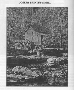
Mostly owned by the Printup family and located in nearby Stone Ridge, this mill was operated for many years, usually by tenants.
5/1/1860 - For $425, William H. Printup bought from Thomas J Sammons 4 acres located between the Canal and the river. On
4/23/1864, it was sold again , for the same price, to Aurie and Fletcher Van Wie.
Another Sale
_4/28/1864 - Arie and Fletcher VanWie bought the former Joseph Printup farm in Stone Ridge from Thomas Sammons. They got 100 acres for $5400. This was added to their other local holdings. By 1869, they were actively growing hops. The best pole wood was chesnut, which was a prominent Montgomery species in that time, and was often utilized in homes and barns. Over the decades, the elegant old home fell into disrepair until 1971, when it was burned by trespassers.
*8/5/1865 - Wm W & Martha Printup sold with 20.97 acres to Steven Wormuth for $1258. The description sounds as it it were rudely surveyed. It is interesting to note that the deed has “L S” (Legal Signature) next to both names on the deed and the handwriting was the same for all, including the notary. Illiteracy is my assumption. The notary had taken Martha aside to assure that she was not being forced by her husband to acquiesce in the sale. Was that normal? Did the notary "smell a nigger in the woodpile"? Does this tell us anything about Wm? There was no reference to an earlier deed.
9/4/1867 - #95, In Convention, p.11 testimony before the Senate and Assembly re. Canals mentions that the sub-engineer under Jenne’s division was named Printup. Section One, under Mr. Johnson, Canal Commissioner Robert C Dorn.
1868 - a map shows Peter Nellis in this location. He had bought it the year prior.
The Modern Era Begins
1880 - first bicycle appears.
*12/1/1880 - Jacob & Kealy Wemple sold it to Wm & Sarah Quackenbush for $375, $300 of which was assumed.
1895 - Automobile appears.
J.N.B. Hewitt, of mixed cultural descent, was proud of both his Indian and white heritage and spent most of his adult life studying the language, culture and history of the Iroquois and other Native Americans. Hewitt became acclaimed as a world authority on Indian lore and spoke fluently in six Iroquoian languages. John Napoleon Brinton Hewitt was born in 1857 on the Tuscarora Reservation in Niagara County. Hewitt’s father, Dr. David Brainard Hewitt was an orphan adopted by the Tuscaroras and raised as an Indian. Hewitt’s mother Harriet was Tuscarora, her maiden name was Printup, probably a descendant of William Printup, Jr., interpreter for Sir William Johnson. She was the daughter of Chief Jonathan Printup and his wife, Eliza Mt Pleasant, a sister of noted Chief John Mt. Pleasant and member of the White Bear lineage of the Bear Clan. (Lockport historical notes)
*2/7/1903 - Sold from Sarah Quackenbush to Levi Starin (prominent local land baron) with just 2 acres. The mortgage was satisfied 6/2/14. I assume it passed, probably by will, from Levi to Frank Starin.
*4/3/1909 - Frank L & Edith B Starin sold to Joseph Moore 60 acres, part of the Bauder Farm. A map from 1905 shows Moore in that location - perhaps he rented it before he purchased it?
*3/22/1910 - Josie L & Fred W. Easton sold to Abram B. Starin & Frank Starin for $10666. The sale included 15 tons of hay, 2 tons oat straw, 3 tons silage, 300 bushels oats, 75 bushels of corn, 2 lumber wagons, 2 hay wagons, a disc and 2 “plowes”, harrows, harnesses. 3 yearlings, 2 hogs, 14 cows and 5 horses. Sounds like a going operation.
*5/9/1919 - M Mark Moore sold to Joseph & Abner Dewey Moore.
*12/26/1929 - Joseph & Julia Moore sold to Abner Dewey Moore, 2 parcels. We have met his relatives and others that knew him. He at one time had a tractor dealership in Fultonville and operated a farm at its edge, which was subsequently developed into housing lots (years and years later). Tom Pullen told us that Harold Moore had been an owner of The Printup Home once and had informed him that there were “shackles” in the basement, supposedly used in conjunction with the Underground Railway. We can find no sign of them and suspect if there was a slave connection, it might have been more concerned with returning slaves to the South than in assisting them to escape. Yet, I was told that it was common to shackle escaped slaves so they would not run out on their own, confused about directions, possibly getting caught in the process. They were shackled and then let loose when there was a guide available for them. I am not sure if I buy this or not. The fellow who told me knows more than I do about such things. Either way, a small area under the little kitchen had some sort of a stone wall there once and could conceivably have been a hiding place. It is in disarray now and when I crawled back in there, I found no sign of shackles.
*11/23/1946 - Abner Dewey & Inez Moore sold to Elisabeth C.T. Miller, 160 acres, in 2 parcels. A 1905 map shows a Joseph Moore in that location.
*7/19/1945 - Elisabeth C.T. Miller of Cleveland sold to Ruth Frasier, wife of Oswald. Again, we know relatives of Ozzie Frasier as well as many folks who knew him. He seems to have gone from one farm to another during his life and was something of a character. South boundary was Joseph Wesselis, West boundary Jane C Yates, North boundary NY Central Rlrd, and it included 100 acres with spring rights to water on Steven Wormuth’s land. A deed from Wm Printup describes this. A second description mentions 60 acres and a monthly tenancy in the home by Raymond VanAlstyne, also the lease of land to Chas. Yurkiewicz, a member of a family who later became prominent farmers, owning thousands of acres.
*8/1/1947 - In 2 deeds, Ruth & Oswald Frasier to sold to Satterlees, excepting and reserving 1.157 acres taken by the Thruway on 2/16/53.
1952 - What is now Route 5S was rerouted over what was called River Road, when the Thruway took over a section of the old 5S. The new 5S became wider, raised, and straighter. One eighth mile east of Borden Rd, it rejoined the old River Rd. The Printup Home lies just beyond this, so the road in front of it was one section that was unchanged. Another eighth mile further east where Spook Rock was, it changed again.
*1953 - deed filed (290/236) listing Wm & Winnie Satterlee, Western Union, Leah Moore, Earl Getman, Ruth & Manuel Rife, George Kehoe
*2/25/1955 - Wm Satterlee and wife (not named) sold to Douglas & Helen Scanlon. Douglas died 8/18/57.
*10/00/1964 - Helen Scanlon sold to Myra Van Alstyne.
*5/00/1966 - VanAlstyne sold to the Zewarts. Many local folks knew and liked the Zewarts (Ziewart) and have told us of visits to the home during the many years the Zewarts owned it. Many local folks remember the Zewarts and have stories of the home. The "History" stops here, but the property was sold in quick succession several times afterwards, sometimes at surprisingly high prices, until it went to a man who apparently intended to turn it into an apartment house. He made only a few changes (thank goodness!), mostly of an additory nature, and then lost it to the bank from whom we purchased it. We don't know his circumstances.
* - direct chain of title
The Printups and Geographical Place Names
The official Montgomery County highway map has at least one mistake. It shows Alston Creek coming into the hamlet of Stone Ridge. The name "Alston" almost certainly derived from the Indian name "Olstona" (or Olstowa, Olsiona, or Olsiowo). However that was the next creek west, whose Anglicized name is Yatesville Creek. Stone Ridge's original Mohawk name was "Wasontha" and there was a Wasontha Kill ("Kill" being a Dutch word for "creek") 2 miles west. The Anglicized name of Wasontha is - you guessed it - Printup Creek. It is where the name "Alston Creek" is shown on the map: Alton and Yatesville Creek are one and the same as are Printup and Wasontha - only these don't show as such on the map. This mistake originated in Jeptha Simms,The Frontiersman of New York (1882) and has been perpetuated ever since. And that map has Stone Ridge erroneously located in the Town of Glen, which it is only near. Stone Ridge produced many cobblestones, used locally for certain buildings. The ridge was 1/4 mile wide by 1.5 miles long. Do not confuse it with an early similar name for the village of Herkimer or the Ulster County town of the same name.
A large smooth boulder, Spook Rock, 5' tall by 6' wide is supposedly just east of the Printup Home. The name came from the irrational fear of saddle and harness horses of its mass and the shadows it cast at night and it became something of a local attraction. It would have been the site of Joseph Printup's death, had not a Tory friend intervened. It was destroyed in 1952 when the Thruway was built. Note: Joseph Printup lived to be 86 and is buried in the Printup Family Cemetery on Dillenbeck Rd (formerly Mill Rd). He died September 12, 1831. There was also a William Printup Cemetery.
1830-32 Stone Ridge Dry Dock 1830-1832 (canal realigned from this course 1857) (Also, see below) (J. Printup 1830, ND; Peter W. & William Printup 1851, 1857) Hamlet of Stone Ridge, Town of Glen, Montgomery County South side of canal 9.0 km (5.6 mi) west to Sprakers; 5.5 km (3.4 mi) east to Fultonville. I believe this would be about a mile further west than the Printup House.
Printup's Basin - a docking area for canalers who could then walk to the tavern on the South Shore Rd. which was operated by Elias Johnson and owned by William J. Printup.
The Printup Quarry was east of Stone Ridge on a steep hillside where there was 2 limestone escarpments,one above the other. It was active during the building of the canal and records show the following: 22300 cubic yards was sold at 20 cents for $4460. This is a substantial amount. Another $1600 was paid for excavation of the stone, and $1960 paid for the embankment of 9800 cubic yards also at 20 cents, for a total payment of $8020. Stone, sold by weight instead of volume, went from 75 cents to $1.32 per ton. Joseph Printup's son-in-law William Smith inherited it in 1833. It was located exactly 1/4 mile east of Smith's home on the River Rd. During the Canal enlargement, Smith had leased the quarry to a firm from Yatesville, just upstream on the Mohawk. Records from 1860 show it was in active use at that time, but little is known about just how active it was and for how long. One may assume that much of the cut limestone found in foundations and other local places may have come from here. We know that 70 yards of stone used in the Fultonville Reformed Church probably came from there.
East of Printup Creek and south of Mill Rd was Sizer's Quarry. This land originally belonged to Joseph Printup, went to Andrew, then John and others not in the family, eventually ending up owned by Mark Loucks, who sold back land to the family for a cemetery. From Mark, it went to Henry Loucks who sold it to Edwin Sizer for $1277 in 1857, after the canal enlargement was finished and the extraordinary need of stone was over. Sizer flipped it on the day he bought it, selling to Aurie VanWie for $1600. Not a bad day's work. Nine months later, Aurie sold it to his daughter Agnes Dillenbeck for $1300. And, I assume, also for "love and affection". But he reserved the land for the mills and the land one which the quarry was presumably located, though the quarry is not specifically mentioned. Maybe we are assigning more importance to this quarry than they attributed to it? This is the quarry that created the waterfalls on VanWie Creek (Borden Rd today). Census records in the Town of Root indicate the 1860employment of a Lars Rickard as a furnaceman, implying that there was also a lime kiln located here. It is likely that one existed here as far back as 1801 during the time Joseph Printup owned the land. The homes constructed nearby all needed whitewash, mortar and plaster and that would not have been carried from far if it could have been avoided. Lime was also used in privies, in tanning, in veterinary medications, in iron and steel manufacture, in paper-making and to sweeten acidic soil, thereby affording greater crop yields. They were typically built into the side of a hill and located adjacent to a stream as large amounts of water were needed to "slake"the lime. A furnaceman was coinsdered a skilled occupation.
The William J Printup Family Cemetery is located - somewhere - on a knoll just south of the Printup Home, 1/2 miles east of the former Glen-Winnie Rd and south of River Road. I have not found it, and conclude it is further south than I have looked. It contains 10 graves, including some who died in a-infancy. Noteworthy "residents" are Andrew, William H and William J Printup. It has been vandalized, tombstones toppled, and is uncared-for.
The will of William J Printup (2/20/1840) notes two Tavern Stands he owned, one of which was in Stone Ridge and the other across the Mohawk at the Sand Flatts (sic). Evert Johnson was the innkeeper of the second one and by 1849 operated the one in Stone Ridge. A Tavern Stand was more than a place to drink. It was a de facto community center. Folks would socialize and exchange news while drinking cider or liquor. A Post Office would be there and of course travelers lent an air of excitement. They were required to be licensed, not that anyone now can find the license for the Tavern operated by Johnson. Lodging was provided, along with food, for travelers. There might be storage space for utensils, barrels and casks of alcohol, hay and so forth. There might be a laundry, a barn for horses and mules and water troughs. And of course a privy. The dining hall would be downstairs and the family and women travelers would be lodged upstairs. A kitchen would be added to the rear where the heat from stoves would not be too much come warm weather. Foodstuffs were purchased locally.
The Grist and Sawmills on Van Wie Creek are all gone, with no sign remaining of what once had been a hub of community activity. They operated for decades and were vital to the area, now they are gone. The waterfalls on Borden Rd are where they stood. The waterfall, like the one on Lasher Creek, was partly created from quarrying, something else you'd' never guess looking at it today. The mills were gone before the quarrying commenced.
The Joseph Printup Family Cemetery (not the same as the William J. Printup Family Cemetery), with dimensions of 25x45', was located on the west bank of the quarry and was undermined by actions there, so much that the gravestones of Joseph & Hannah Printup, John & Cornelia Printup, Dr. Joseph Printup and a David Zielly were moved to the public cemetery in Fultonville. Some stones had tumbled 40' (sic) in their fall into the quarry. The remaining headstones may have been thrown down the hill, rather than fallen, completing the desecration.
Transportation Conduits:
The Western Inland Lock Navigation Company, incorporated as a private company in 1792 but founded by an act of the legislature, was the precursor to the Erie Canal. The Mohawk was too shallow or had too many obstructions and rapids for boats of any size to navigate, so shallow-bottomed boats (bateaus) of smaller size were all that could operate there. This firm did some dredging and obstruction removal and erected what they called "wing dams" in an attempt to raise water levels where rapids were. Landing places were created. Typical freight include ginseng, potash, and pearl ash as well as food supplies raised locally. Their improvements were completed in 1803, but in an attempt to recoup their investment, tolls were so high that goods tended to move by land instead, as roads were also being improved.
Just west of Printup (Wasontha) Creek, was Henry Ten Eyck's Rope Ferry across the river. We know from a deed to Joseph Printup that it existed as early as 1801, but we don't know when it was started. Ten Eyck had acquired the lot on which it was located in 1790. George Hewson was the ferryman and probably leased the operation from Ten Eyck. One and a half miles east of Stone Ridge was Aaron Veeder's Rope Ferry, operated with a succession of owners, from 1828-19844. This would have been a bit east of The Printup Home. This gave direct access to the "Road to Johnstown" (now Martin Rd), the Court there, the jail, and the center then for business and legal matters. In 1836, Montgomery County was formed from the larger Tryon County and Fonda became its County Seat, Fulton County being formed from Tryon County 2 years later. From 1820-25, John Jervis, an engineer for the Erie Canal, kept an account book and in it is a mention of a bridge over the Canal for the "J Printup Ferry Road". I wonder if this was the origin for the raised road that forms the western boundary of The Printup Home. The implication is that Printup had a ferry as well.
In 1808, Jesse Hawley first presented to the Legislature a proposal for the Erie Canal and a small appropriation was made to survey a route. Two years later another survey was ordered, but the War of 1812 intervened and it was not resumed until 1816. A survey crew of 12 men stopped on one of the Printup houses during the survey. In 1817, DeWitt Clinton's act passed , allowing construction to commence. Clinton had lived at one time at a farm near Ames. They started on July 4th, at Rome. The canal was to be 40' wide at the surface, 28' at the bottom, 4' down and was to be 363 miles long. The canal, in the area of the The Printup Home, presented numerous challenges due to the proximity of the many solid rock escarpments, which had to be cut back in places and protective walls erected to avoid damage by recurring floods. Several creeks enter the river in this area and had to be contended with as well. They had their own floods as well as backup floods from the river and there were all sorts of devices erected to deal with these problems: guard locks and gates,stone and timber aqueducts, culverts, feeder dams, plank aprons, breast dams... It was in 1821 that the actual construction commenced in this area and William J Printup was listed as a contractor for one section. A bridge, referenced above under "Rope Ferry" was built for him. Printup Creek got a feeder dam and a bridge built across it as well. William J's contract required him to "embank and construct Section 95 of the Eastern Section of the Erie Canal". He was paid $150 for clearing and grubbing land, 8 cents/cubic yard to excavate underbanks and 12.5 cents/cubic yard to embank it. He also supplieid timber and planks, sawed at the Printup sawmill no doubt. He also built guard gates on another section of the canal.
If you were an able-bodied man in the Stone Ridge of 1821, you probably worked on the Canal or in the Printup Quarry. You may have hired out your horse teams and wagons, boarded laborers in your home, and sold them food and hay and grain. If you had a store,; it was a good time and your booming sales of tools, clothing, liquor, hardware and harness would have made for extra, though temporary, prosperity. Records show William J Printup received $11.40 for removing fences, $60 for labor and moving buildings, then, on the next section of canal, $1780 for more labor, $238.44 for timber and planks for a guard gate. He also got $438 in damages. John Printup made $32.35 for working 7 days excavating 58.25 rods, ditching and 26.25 rods of cleaning out, and $7.90 to cut back drains on 2 sections. (The canal went through both Joseph and John's land at Stone Ridge.) I love these payments made to the very cent. You won't see New York State do that today!
On New Year's Eve of 1824, Joseph Printup was listed (without a dollar figure shown) for purchase of 1/2 acre of land for 8 years (sic.) for repairs on the canal. This became a widewater basin. Built of timber piers as a dock for canal craft while they were being loaded or unloaded with construction materials (clay, gravel, rock, and other things). Printup's Dry Dock was constructed 10'deep and located adjacent to a v-shaped basin on the south side of the canal. A guard gate provided entry and then water was drained so the boat could undergo repairs. It was a casualty of the canal enlargement in 1857 and little information on it survives today. It was part of land sold by William J to his son-in-law William Smith as part of 3 acres ($300) on 3/16/1836.
There was also a Feeder Dam across the Printup Creek, the water of which assisted in maintaining water level in the Canal. It was built with limestone wings and timbers filled with cobblestones for the actual dam and spillway. The quarried stone survives today. An Aquaduct of Printup Creek was built similarly, with arched chunks of stone over which went a trough of wood and the canal. John Printup was paid for the excavation of this (see above).
This period of construction was not easy on landowners. "The owners of the land...are subject to many inconveniences. Their fields are thrown open, or their fences are new laid, for temporary security, while the work is going on. The trees... are grubbed up and cleared away, or felled forthwith to a width of 8 rods....And while the embankments are incomplete, new channels are provided in many cases, which subject the adjoining lands to more or less hazards of injury. Where excavation is begun, drains must be opened, which will naturally discharge all the water running into the excavation. And, in times of heavy rain, this will be in such quantity, wherever the line of excavation is long, and the drain from the land into it is extensive, as to produce torrents of sufficient power to gully and deface the ground below." (NY Canal Laws, p.466)
A Herkimer physician, Andrew Bartow, is credited with the implementation of "quick lime" in Canal construction. Placed under water, quick lime hardened, functioning as cement, and making the limestone blocks that it was built from not only more stable but also more watertight. Between Schenectady and Little Falls, the following were completed in 1823: "13 locks, built of limestone, handsomely cut and laid and grouted with water cement, 11 guard locks built partly of hewn and partly of well shaped rough stone and laid in water cement, 60 culverts of various sizes of limestone masonry, 13 aqueducts with piers and abutments of stone masonry, trunks of wood, 105 road and farm bridges, some of them with abutments of stone, but the principal part built of timber and plank, 6 dams of timber filled with stone wings of stone masonry: (NY Canal Laws, V II, p111). If you have seen parts of the Canal (they are in many places to see, if you look closely and intelligently), you will agree that they are indeed "handsomely cut and laid", lost skills in our time today.
When the Erie Canal was in process of construction, almost every house near the line of the work was a "tavern". Most of these extemporized hotels only existed while the canal was building, although some of them were kept up thereafter, and did quite a thriving trade with travelers on the canal. Among others which came into being about this time, was one of which Richard Hughesen was the proprietor. The building, a small frame structure painted red, is still standing. Peter Fonda kept a tavern about a quarter of a mile below that of John Starin, and John Gardiner one as much further down the river, while Rynier Gardiner kept one at the same distance still further east. Several other small places of entertainment for man and best were established along the south bank of the canal from 1825 to 1828, but those mentioned above were among the principal ones. (“The History of Montgomery and Fulton Counties, NY” by FW Beers & Co. 1878.). In this vicinity, it was completed in 1825. Another source mentions that it was opened to Albany in 1824.
Canal Changes:
By 1835, it had become apparent that the Canal's success was such that it needed to be widened and deepened and an act was passed to accomplish this, including the construction of some double locks (allowing boats to continue on their way while another boat was heading in the opposite direction). A period map shows that William H Printup, east of Stone Ridge, had both a grocery and a barn. See the map at the very bottom of this page.
1855: NYS appropriation to enlarge the Lasher, Yates, & Printup aqueducts to the canal. The names refer to creeks. The canal had been enlarged in 1853, taking precious river flat land from some landowners. By now, it had established itself as a source of local income. From Coddington: "An added incentive for purchase of the former Printup farmstead was instant access to the economy provided by the Erie Canal, by means of a 'wide-water basin' that had been constructed on the south side of the Canal, adjacent to a large gravel bed on this land. Gravel was needed for repairs and continual maintenance of the Canal. The basin accommodated docking of canal boats, to load or off0load passengers, supplies and goods such as quarry stone, lumber, logs, equipment, stock, grain, hay, etc. It was also a place to turn packets or scows around."
1/1/1858 - a map (shown above) shows location of The Printup Home and barn, along with the Old and New Canals, the Mohawk River, and 13.89493 acres of fields being taken by the enlargement of the Erie Canal. This map was apparently drawn for a lawsuit of Wm I Printup asking for what must have been quite high recompense at the time. Part of the land is described as “dug over”. I assume the following information is directly related; the acreage numbers are off by exactly one acre. William H Printup had 7.89873 acres permanently appropriated, for which he received $1184.80, to which was added $414.65 interest. Also there was 4.9962 acres "dug over" for which he received $125/acre - $624.52. He also got $300 for injuries and the dislocation of buildings. The lands affected were considered the best Mohawk River flats soils, but the damage done was not permanent. He was awarded $2523.97. As an aside, Documents of the Assembly of the State of New York, V II, 1858 shows D.H. Printup received $83.33 for services as a clerk to the Canal Commissioner.
In 1906, work commenced on the final enlargement of the Erie Canal. This time the river itself became the canal and, finally, ocean-going ships could be accommodated. To accomplish this, the river was periodically dammed and locks would bring ships around the dams. Today, this is still used, but mostly for pleasure boats . It is now administered by the Thruway Authority. In 1906, it was planned that the channel would be 75' wide at the bottom and would be 12' or more deep. Dredging and discharge of effluent from it led to widespread destruction of some river flats. Once again,"progress" came at the expense of food production. But it was worse than just altering the topography by dumping river bottom waste up to 12' deep on to good soil. Damming of the river caused the water table to rise and large tracts of otherwise-unaffected land now became too wet to use. You cannot drain land when the water has no where to go.
In 1836, the Utica and Schenectady Railroad was running for passengers, which utilized the north side of the Mohawk. The following year, they began hauling freight as well. In 1881, construction commenced on the New York West Shore and Buffalo Railway. Passenger service to Syracuse began 2 years later. But by 1885, the firm was bankrupt and the lines were absorbed into JP Morgan's New York Central. Rail service here ended in the 1980s and the rails were taken up. New York State now owns this land and it is used as Bike Path, which, when finally complete, will stretch from Albany to Buffalo, traversing some very historical ground along the way.
River Road followed an Indian trail and quite naturally was widened and improved by the first settlers who had need for a road, not a trail. There is a 1760 map of it. It was used for military operations during the Revolution. Prior to 1800, the South Shore Rd (now Route 5S) was more important than the Mohawk Turnpike (now Rte 5). On the latter, there was an inn about every mile, as it was a lucrative business, especially for those that could provide stabling. For those that didn’t, the horses were covered with an oil cloth. Now River Rd (South Shore Rd) has been supplanted by Rte 5S and is still a major thoroughfare. in 1806, it was widened and improved, utilizing higher ground, thereby avoiding problems when the Mohawk and the creeks flooded. In the vicinity of The Printup Home, its course can be found as follows: heading east from the banks of Van Wie Creek (Borden Rd vicinity), it ascended a bit, flanked by large elm trees (gone now, thank you Dutch Elm disease), with a 2' high cobblestone and quarrystone wall on either side, with 47' between the walls. By The Printup Home, it is the same as 5S and stayed below the lower level of the limestone escarpment just east of the home. In this area, the Canal closely paralleled River Rd. The subsequent enlargement of the Canal in 1853 did not affect River Rd as the canal was moved north. Southwest from there, remnants of the Printup Creek feeder dam to the Canal are evidenced by a 4' high wall of cut limestone, held together by quick lime, and erected diagonally to the creek bed. The creek itself has had its course altered by man over the years since. In the vicinity of the Joseph Printup home, which stood on a knoll nearby, there was a wooden bridge over the creek. River flats to the north had had to be abandoned after the construction of the Thruway. Some found the water table altered and became too wet for their ditches to function; others were just no longer able to be accessed. Where 5S enters Fultonville, it is on top of the old Canal towpath. By The Printup Home, an access road connected River Rd to the new 5S. This is now the western border of our property and serves as access to the Bike Path today.
The NY Thruway in the vicinity of The Printup Home was built on top of the original Rte 5S and Rte 5S was subsequently relocated on top of River Rd. At this point 5S was elevated 3-6' and further widened, which explains why the road is located above the grade of the home. Going through Stone Ridge, 5S basically used River Rd, and the State put culverts for creeks where it wanted and then diverted the creeks so they flowed under the culverts. An S curve, placed originally to avoid mucking up the river flats and protecting the road from flooding, was eliminated. East of The Printup Home, 5S went higher than before and was placed on an upper escarpment. This is when Spook Rock was dynamited away.
In 1954, what is now Rte 5S was displaced by the Thruway (now I 90) and was removed to its present location, forming the south boundary. the west line was the road that once lead to a canalway bridge. The northern boundary of the triangular-shaped lot was the old New York Central Railroad, now the Bike Path. From 1952-54, much gravel and crushed cobblestones were taken from this area and used in the Thruway construction. Quarries, began after the construction of the Erie Canal, became more active as well. Between the Cal and the Thruway, the topography of this are is quite altered from the way the first settlers must have found it. It is much more level today. Along with the topography displaced by Thruway construction were the old cobblestone-lined historical boundaries between properties.
The New York West Shore and Buffalo Railway, tracks of which were removed in the 1980's, was built in 1881. It's right of way is now used by the Bike Path.East of The Printup Home, the double tracks were placed close together on the lowest escarpment, but still above Canal level. At this point, River Rd had to be diverted a bit.
Maps Found
USGS 7.5' Randall, UTM 18.4753520mN 547050mE
Maps showing this site: 1830, 1832
Maps in which the site is not present: 1851, 1853, 1857, 1896, 1913
Maps investigated for this site include:
1830 Holmes Hutchinson Series 9:26
1832 Structure Book 89:42
1851 Structure Book 22:14a
1851 Structure Book 35:29
1853 Montgomery County Land Ownership Map #0521
1857 Structure Book 38:4
1913 Blueline 3-101
1896 Schillner Series 9-3
"old" Structure Book 37:24
Also, see below.
Next page, Location.
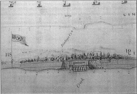
The proposed aqueduct over Van Wie's Creek, 1851
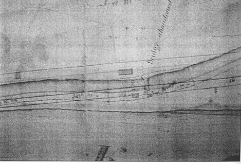
Erie Canal Enlargment, area of VanVranken Flatts, and location of William H Printup's store and barns.
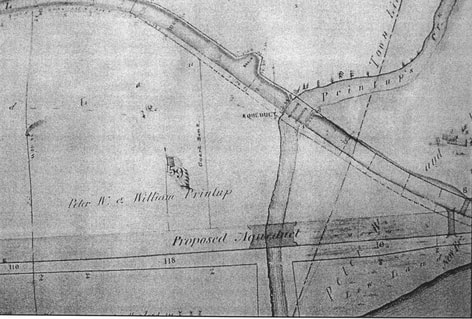
The 1822 Erie Canal, Printup Creek Aqueduct
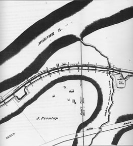
Stone Ridge and the Printup Dry Dock
